Shallow groundwater flow in weathered hard rock areas typically focuses on fractured weathered zones, which are often simplistically conceptualised with a uniform thickness and permeability. This ‘transition zone’ is typically encountered as a horizon of increased, then decreasing, hydraulic conductivity occurring between the base of the weathered saprolite and the underlying fresh bedrock.
However, this fractured zone is not always a simple, laterally extensive layer with uniform depth. In metamorphic terrain it can be formed from a number of weathering events at different elevations. Weathering around subvertical features like faults and dykes can cause localised variation in depth and associated hydraulic properties.
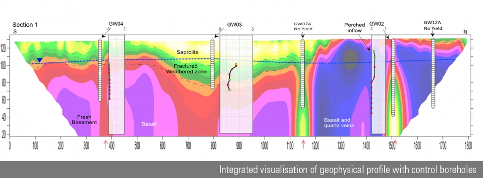
Over simplifying the weathered zone into a layer of uniform depth and hydraulic properties using only limited hydraulic measurements can lead to misleading interpretation resulting in ineffective remediation designs and monitoring programmes.
In recent projects, SRK has combined targeted hydraulic data with surface geophysical data to improve our concept of the weathered fractured zone. The primary surface geophysical technique used has been Electrical Resistivity Tomography, although other methods have been tried with less success. Geophysical results have been combined with drilling data (core logs and geotechnical logs) and compared with the results of vertical hydraulic profiles derived from packer tests, spinner tests or drilling airlift results. LeapfrogTM 3D geological modelling software has typically been used for compiling data. This approach enables the resistivity tomography sections, borehole data and hydraulic test data, as well as other geological interpretation, to be combined for subsequent interpolation of the weathering interfaces.
The variability in hydraulic conductivity results can be related to local variations in the weathered fractured zones when adopting this approach. The improved conceptualisation and understanding of the spatial variability of the weathered zone in-turn provides a more realistic representation of the system in subsequent numerical groundwater modelling.
Integrating geophysical data with geological and hydrogeological information has been instrumental in recent contaminant transport investigations of leaking tailings facilities. The approach allowed us to identify and characterise laterally extensive pathways of deeper weathering that act as permeable channels for solute migration.
Careful selection of the geophysical method is required, based on the local geology and groundwater depth, with initial field trials at each site before the main investigation. Additionally, ground-truthing the geological and weathering profiles from boreholes along geophysical survey lines has proved highly effective for accurately interpreting geophysics profiles.